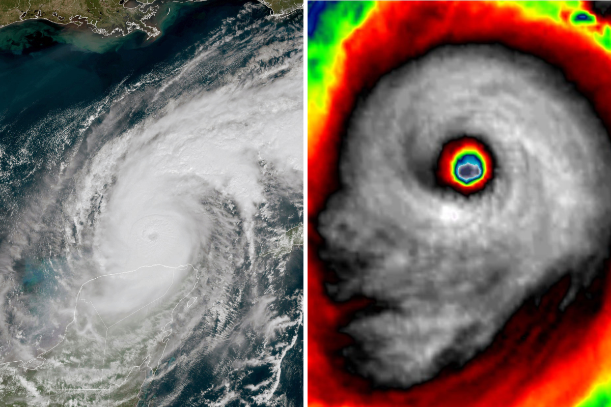
Eerie satellite radar footage of Hurricane Milton forming a skull-like shape is going viral on social media ahead of the storm’s landfall, which is expected to have a catastrophic impact on Florida starting later on Wednesday evening.
Stu Ostro, senior meteorologist at The Weather Channel, posted side-by-side photos of sinister-looking faces of Hurricane Matthew in 2016 and Hurricane Milton on Tuesday.
“The original skull face with #Matthew in 2016, and #Milton tonight. Both are “M” storms. Interesting that intense hurricanes can be conducive to having that structure,” Ostro wrote in a tweet with over 559,000 views.

AP Photo/X/@StuOstro
Severe weather YouTuber Max Velocity, who has 520,000 subscribers on the platform, also tweeted a photo of Milton’s “creepy skull” on Tuesday. At the time of publication, his tweet has over 284,000 views.
Another X user, Storm Chaser Rob from Alabama, shared a video of the satellite radar forming the unmistakable figure, writing, “We have a SKULL. This is a harrowing visual. This sent chills up my spine. Hurricane Milton will be talked about for a long time.”
Wednesday morning, Hurricane Milton slightly weakened over the Gulf of Mexico into a strong Category 4 storm with winds of 155 mph – just slightly below the Category 5 threshold, according to the National Hurricane Center.
In October 2016, Hurricane Matthew caused significant damage across several Caribbean nations and Florida.
Hurricane Matthew was particularly devastating in Haiti, where it made landfall as a Category 4 storm, causing severe flooding, landslides, and extensive damage to infrastructure. It was estimated that over 500 lives were lost, and tens of thousands were displaced, with widespread destruction of homes and agricultural lands.
Eastern Cuba, the western Grand Bahama Island, South Carolina, and Florida also got hit. The total economic impact of Hurricane Matthew across all affected regions was estimated to be over $15 billion.
Tracking Milton
Hurricane Milton is forecast to make landfall near the Tampa Bay area Wednesday night, bringing with it extremely powerful winds, intense rainfall, and catastrophic storm surges.
“The track of Hurricane Milton continues to be a worst-case scenario for the Tampa Bay region southward to Charlotte”, the National Weather Service in Tampa Bay said in a briefing Wednesday morning.
Governor Ron DeSantis issued emergency orders over the weekend that now include 51 counties. Evacuations are particularly important along Florida’s west-central coast, where storm surges could be more than 10 feet in some areas.
Tampa Mayor Jane Castor has issued several blunt warnings to residents ignoring evacuation orders, telling CNN on Monday, “If you choose to stay … you are going to die.”
On Tuesday, Castor doubled down on that sentiment, telling residents in an address “Individuals that are in these, say you’re in a single-story home … two feet is above that house. So, if you’re in it, you know, basically that’s the coffin you’re in.”
“I’ve said many times that you want to pick a fight with Mother Nature, she’s winning 100% of the time,” she added.
Stay informed about the latest on Hurricane Milton by joining Newsweek’s Facebook Group Hurricane Milton: Breaking News & Updates.


